Big Pixel
- About
- People
- Projects
- News
- Contact Us
Detecting Urban Markets with Satellite Imagery: An Application to India
July 2018 | Draft Paper
Professor Gordon Hanson and co-authors abstract: This paper proposes a methodology for defining urban markets based on economic activity detected by satellite imagery.
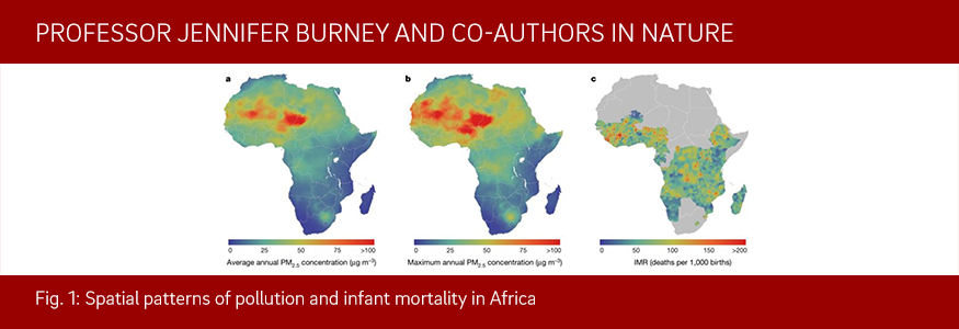
Robust relationship between air quality and infant mortality in Africa
June 27, 2018 | Nature
Professor Jennifer Burney and co-authors discuss poor air quality is thought to be an important mortality risk factor globally, but there is little direct evidence from the developing world on how mortality risk varies with changing exposure to ambient particulate matter.
Can You Hear Me Now? How Communication Technology Affects Protest and Repression
March 29, 2018 | Quarterly Journal of Political Science
Professor Francisco Garfias and co-authors abstract: Commentators covering recent social movements, such as the Arab Spring, commonly claim that cell phones enable protests. Yet, existing empirical work does not conclusively support this contention: some studies find that these technologies actually reduce collective action; many others struggle to overcome the selection problems that dog observational research.
A living, learning laboratory: Inside the Geo4Dev symposium
Sept. 29, 2017 | GPS News
Led by Ran Goldblatt and featuring GPS faculty, this international development symposium seeks to address our world’s greatest challenges, at scale, with the UC San Diego Big Pixel Initiative.
Big Pixel Initiative Develops Remote Sensing Analysis to Help Map Global Urbanization
Sept. 8, 2016 | UC San Diego News
Researchers at the University of California San Diego’s Big Pixel Initiative are using unique tools to map urban areas around the globe, potentially revolutionizing large-scale analysis of urbanization. Using Google Earth Engine, they developed and tested new machine-learning approaches that use high-resolution satellite data to detect and map settlements around the world.
Getting the Bigger Picture
May 12, 2016 | UC San Diego News
Students across campus are being taught to understand the technology that affects our lives, every single day. And in the process, they’ll graduate more prepared for jobs that have the potential to make positive, real-world change.
Putting Google Earth Engine on the map at UC San Diego
Jan. 20, 2016 | GPS News
Ran Goldblatt brings to Global Policy and Strategy more than just his expertise as a geographer and GIS analyst but also a determination to equip students with the latest tools of the trade.
University Students Turn Satellite Images into Policy Analysis
June 15, 2015 | UC San Diego News
Over 50 students – most of them graduate students participated at the Big Pixel Hackathon to Discover the Planet. The hackathon was organized by the Big Pixel Initiative (BPI) to showcase what can happen when you let students loose on the largest private collection of high-resolution satellite imagery on earth.
UC San Diego Granted Access to DigitalGlobe Commercial Satellite Imagery
March 18, 2015 | UC San Diego News
The DigitalGlobe Foundation has selected the University of California San Diego to be one of two institutions of higher learning given open access to DigitalGlobe Basemap, an online map and database of current, high-resolution satellite imagery – of the entire planet.
Representative Surveys in Insecure Environments: A Case Study of Mogadishu, Somalia
March 1, 2014 | Journal of Survey Statistics and Methodology
Professor Jesse Driscoll and co-author conducted a representative survey of Mogadishu's population—the first in 25 years—in March 2012.
Presentation at the Google Earth Engine 2015 user summit: Ran Goldblatt presented the Big Pixel Initiative at Google's Google Earth Engine User Summit. Watch Video
Incredible Satellite Images Show China Building Artificial Archipelago: It seems strange that a remote patch of water would become the focus of international controversy and millions of dollars worth of infrastructure. But that’s exactly what’s happening in the South China Sea right now. Read More
Moving Toward an Evolutionary Theory of Cities: This article evaluates the science of cities... how cities grow, and what influences their characteristics. "are we getting closer to an evolutionary theory of cities?" or is it inherently unpredictable, given that cities are made of individuals? Read More
Global Forest Change: This paper by Hansen et al is the first map of global forest cover change using Landsat data. This is a major step forward in marriage of satellite image processing and big data. Read More
The Invisible Borders That Define American Culture: In this digital age, we are still very much a product of place. What can we detect from the sky that would enlighten the results in this article? Read More